Economic Development
Overview
St. Louis County enjoys an abundance of natural resources, including forests, farmland, lakes, and mineral deposits. The county’s mining, logging, and agricultural traditions date to the mid-19th Century. Since then, the county economy has expanded to support a diverse array of industries.
Resource-based Economy
Many industries play an important role in the St. Louis County economy. Resource-based industries are particularly relevant for the County Comprehensive Land Use Plan, because they require substantial land and produce environmental impacts. Resource extraction, harvesting, and associated industries must be carefully managed to contain environmental impacts and ensure sustainable rates of production.
Given the county’s history of mining and its untapped mineral potential, one of the primary objectives of the County Comprehensive Land Use Plan is to protect opportunities for future mining activity. Another goal is to employ sound land use and environmental management principles to limit the external impacts of mining on adjacent land uses. The Plan will accomplish this by limiting non-mining development in and around areas with resource potential, and guiding it to more appropriate areas of the county. (See Figure 2.4, Mining Impact Areas Map.)
Employment and Wages
The two main indicators of economic well-being are employment and wages. Some industries, like mining, pay extremely well but employ relatively few workers. Others, such as accommodation and food services, employ considerably more workers but have much lower incomes. Economic development initiatives often seek to increase the share of workers with high-paying jobs, which improves personal well-being and public finances, and expands opportunities for continued growth.
Industry Trends
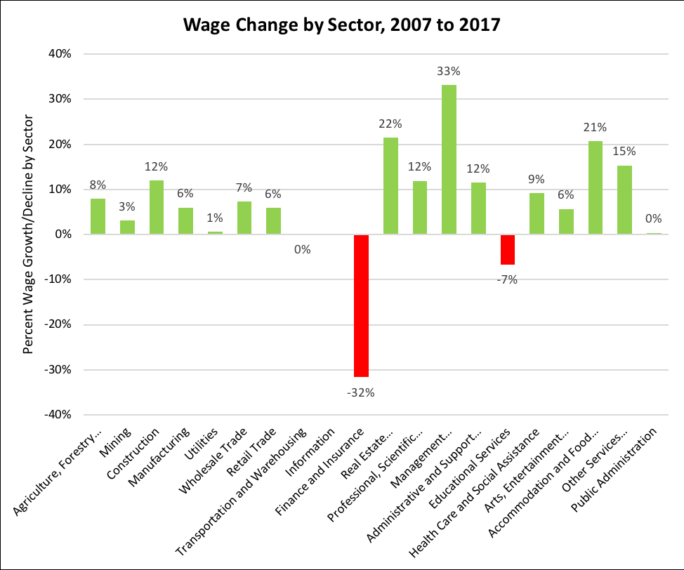
Understanding industry trends is key for targeting economic development strategies. The following charts highlight industry employment and wage trends for each sector in St. Louis County from 2007 to 2017. Note that most sectors saw growth in both employment and wages over this period. A new sector, information, was added. Health care saw the greatest increase in total employment, while manufacturing saw the greatest decrease. Business management saw the greatest increase in wages, while finance and insurance suffered a substantial earnings loss (32 percent decrease).
Figure 2.1 –10-Year Employment Trends
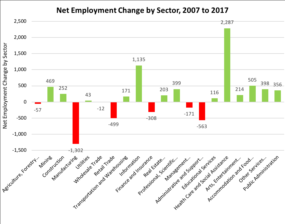
Source: Quarterly Census of Employment and Wages, 2007 and 2017. Data contains all public and private industries.
Figure 2.2 –10-Year Wage Trends
Industry Specialization
St. Louis County specializes in several industries, most notably mining. The degree of specialization in any industry is measured by the location quotient (LQ), which compares local industry employment or productivity relative to the national average. For example, in St. Louis County, all mining and quarrying activities employ 4.4 times as many workers as would be expected for a population this size – in fact, St. Louis County ranks third among all counties in the U.S. using the LQ metric.[1]
[1] https://datausa.io/profile/geo/st.-louis-county-mn/#economy
Economic Base
The economic base is composed of industries which produce goods or services for export. Basic industries bring new wealth into St. Louis County. Any industry with a location quotient greater than 1 is a basic industry. Any industry with a location quotient less than 1 is a non-basic industry. All natural resource-based industries are part of St. Louis County’s economic base. The County Comprehensive Land Use Plan supports these industries by ensuring long-term access to natural resources, promoting sustainable resource management, and minimizing conflicts between incompatible land uses.
Economic Clusters
The U.S. Cluster Mapping Project provides further insight into the St. Louis County economy. A “cluster” of industries is a group of supportive industries that are linked through their supply chains. This happens when the goods and services that are produced by one regional industry become inputs to production in another industry. Firms selectively cluster together within a region when there is benefit in locating near other similar firms.
Figure 2.3 provides a visual summary of St. Louis County’s economy. Each circle represents an industry group. All green-colored circles represent areas of economic specialization (basic industries), with the relative degree of specialization indicated by shade. The connecting lines represent relationships between supportive industries, demonstrating the cluster effect.
Note that metal mining and forestry are both specializing industries, but they are not highly integrated into the regional economy – that is, raw mineral and timber products exit the regional economy for material processing and application. If ancillary industries were to develop locally, the county would be able to further capitalize on its primary resources.
Figure 2.3 – St. Louis County Industry Clusters
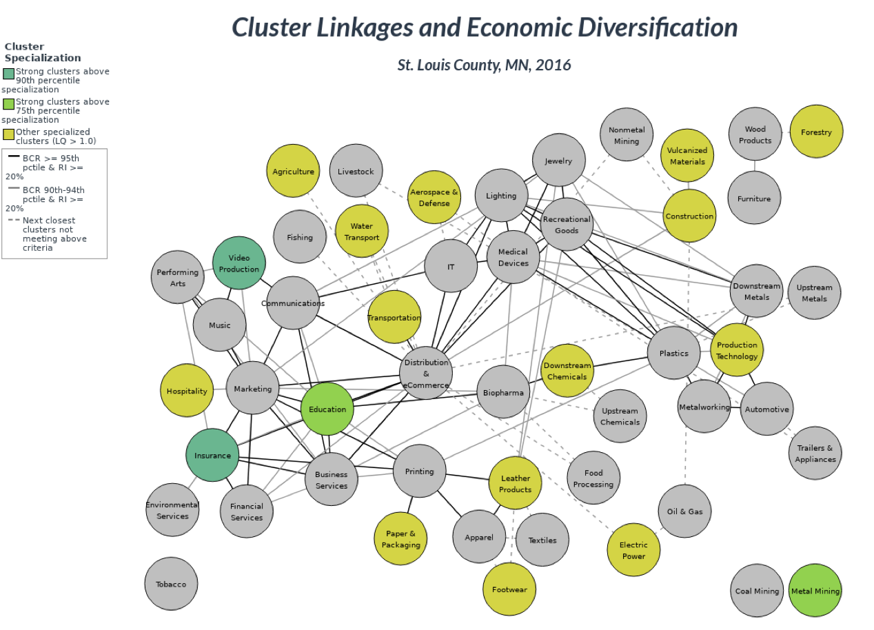
The big takeaway from this cluster analysis is: Economic development initiatives should be coordinated, with the goal of improving conditions for groups of related industries, rather than focusing on just one industry.
Related strategies include:
- Build on the unique strengths of St. Louis County and northeast Minnesota, rather than trying to be like other regions.
- Engage in dialogue with cluster industries. Public policy is rarely the main factor in the investment and locational decisions of private industry. Still, St. Louis County can play a central role in developing relationships and supporting regional partners.
- Develop cluster-specific strategies. Each cluster has different needs. For example, technological advances within mining and related industries may require specialized support, such as technical jobs training and assistance with technology deployment. These needs are different than those for the education or insurance sector.
- Provide opportunities for new clusters to emerge. St. Louis County can partner with local communities, schools, and industry leaders to promote and maintain economic conditions that support cluster growth. For example, new clusters may develop if there is sufficient capital flexibility and knowledge creation (for example, through postsecondary education).
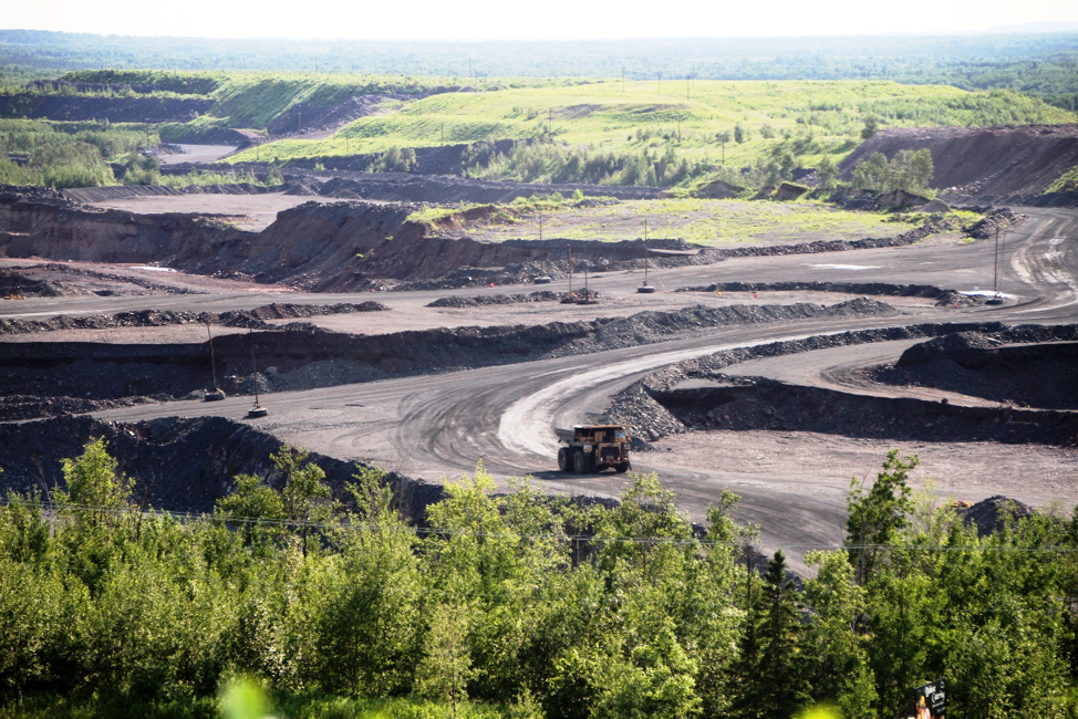
Mining
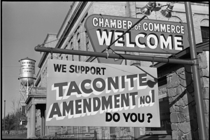 St. Louis County’s Iron Range is mining country. The discovery of gold in the 1860s led to further mineral exploration, which ultimately led to the discovery of the largest mining district in North America, the Mesabi Iron Range. Mining jobs pay considerably well – consistently between $75,000 and $95,000 per year, depending on production. This is well above the county’s median household income, which is roughly $50,000. Still, mining employs just over 3 percent of the county’s population. If mining and ancillary industries were significantly expanded, there may be a substantial opportunity to increase household incomes.
Figure 2.3 shows that metal mining is one of the strongest industries in St. Louis County. However, it is not connected to any other cluster in the diagram. The reason is that all raw mining products are currently exported for further refinement and processing. What is missing are subsidiary users of raw taconite and processed steel, and potentially users of taconite tailings. By developing ancillary industries within the county, the county would further capitalize on primary mineral production before raw product leaves the county.
County industries which are linked to mining include engineering and consulting, machinery and technology development, logistics and transportation, and energy and water supply. Each would expand with increased mineral extraction.
Non-Ferrous Metals
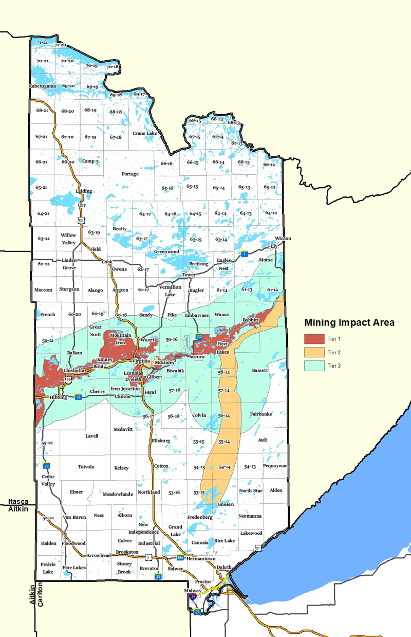
The economic and environmental impacts of non-ferrous mining have been studied at length. The Minnesota DNR oversees all state and federal permitting requirements. Currently, no operation is permitted to mine non-ferrous metals in St. Louis County. Several applications are pending. The County Comprehensive Land Use Plan acknowledges the potential for non-ferrous mining in the Duluth Complex. (See Figure 2.4, the Mining Impact Areas Map.)
Taconite Tailings – Waste or Resource?
Taconite tailings represent one-half to two-thirds of all processed ore. Usually, this material ends up as waste product, contained in tailings basins. But taconite tailings have many useful properties, including high strength, durability, and hardness. Thus, the material can be a “green” alternative to gravel and substitute additive in asphalt. Tailings have been used in road construction in Minnesota since the 1960s, although this use has not been widespread. Because tailings are denser than traditional aggregate, the cost of shipping is higher. On the other hand, the initial cost of resource “production” is essentially zero (transportation costs only), since tailings are purely a byproduct of iron mining. St. Louis County’s tailings stockpiles could have future potential. By engaging with mining industry, freight providers, construction, and research institutions, the County will keep its options open.
Mining Areas
Ferrous mining occurs in the Iron Range, a band of mineral deposits that runs east-west across central St. Louis County. Non-ferrous minerals are largely contained in the Duluth Complex, which is located adjacent to the Iron Range. The County Comprehensive Land Use Plan refers to the Iron Range and the Duluth Complex as mining impact areas. The Iron Formation is Tier 1. This area is actively mined. Areas of more active non-ferrous exploration and mineral lease activity in the Duluth Complex (and an area north of Virginia) is Tier 2. The boundary of Tier 2 encompasses the general co-location of exploratory borings, active mineral leases, and known mineral prospects. Tier 3 extends beyond the mining formations to include ancillary uses, such as tailings basins. Because tailings basins are located up to 7 miles from the mineral formations, the Tier 3 boundary extends 7 miles from Tiers 1 and the more actively explored portions of Tier 2.
Given active mining and the potential for industry expansion in these areas, the county will proceed cautiously with permitting of uses that are not related to mining, especially within Tiers 1 and 2. This discretion is needed to preserve opportunities for mining industry growth, to mitigate environmental hazards, and to avoid potential land use conflicts before they begin. This approach is intended to provide clarity to all current and future owners of land and minerals within the mining impact areas. In the future, new land use policies, such as a zoning and subdivision regulations, could be applied to these areas. (See Figure 2.4, the Mining Impact Areas Map.)
Figure 2.4 – Mining Impact Areas
Forestry
 The forests in northeast Minnesota are some of the most productive forests in the nation. St. Louis County provides the most timber in Minnesota (more than 600,000 cords in 2011) – nearly twice as much as Itasca County, the second-most productive county. Many landowners earn a stable income leasing land for timber harvesting. Yet the number of forestry-related jobs is comparatively low, because there is a lack of forest products manufacturing facilities. Given the county’s local advantages in timber harvesting, transportation, and construction, there is potential to further develop forestry-related cluster industries.
St. Louis County’s role is to facilitate dialogue between various public and private agencies throughout the region, and to provide assistance as it is able. The goal is not necessarily to expand timber production, which employs a small fraction of the county workforce, but to develop local industry linkages to further capitalize on the timber resource before it leaves the county. Ancillary activities/industries include milling, paper, construction, packaging, biofuels, and new mass timber applications.
The biggest challenge is location – the county’s raw timber resource is located far from the primary users of end products. Usually, it is cheaper to ship raw materials to centralized processing and manufacturing locations than it is to ship finished product long distances for consumption. While St. Louis County has little influence on U.S. lumber markets and supply chains, it can promote the development of local markets to create new employment opportunities.
Many forest landowners earn income from timber harvesting on their property, even though they aren’t directly employed by forestry enterprise. Forest landowners who are interested in timber harvesting and forest stewardship should contact the St. Louis Soil and Water Conservation Districts (North or South) to develop a Forest Stewardship Plan. Landowners with a current Forest Stewardship Plan may be eligible for State property tax relief.
The Forest Agriculture or FA future land use category is used to maintain large tracts to support sustainable timber production and limit non-forestry development in and around working forests. All development applications and infrastructure proposals in and around these areas will be evaluated for impacts to forestry conservation.
Agriculture
St. Louis County residents are proud of their community’s agricultural heritage. Like mining and forestry, farming provides opportunity to make a living off the land. The gross market value of annual agricultural products is more than $17 million. The 2012 Census of Agriculture estimated that there are 127,000 acres of active farmland in St. Louis County (crops or livestock production). However, the total agricultural area, the number of farms, and the average size of farming operations have decreased consistently since 2002. This trend toward consolidated commercial farming is not unique to St. Louis County.
Agricultural goals and policies are oriented toward preserving farming acreage, increasing productivity, and expanding employment opportunities in farming and related clusters. The agriculture and livestock industries are connected to transportation and technology industries, indirectly supporting many jobs. Economic development should focus on enhancing these supportive structures, in addition to promoting primary production industries.
Like forests, farms are working landscapes that require active management to sustain long-term production. There are two main threats to farmland conservation: 1) the conversion of farmland to development, and 2) diminished soil quantity/quality, which is largely due to natural erosion. St. Louis County employs several strategies to address these threats:
- The Forest Agricultural Management district (FAM) is used to delineate agricultural areas, provide preferential tax incentives (such as the Green Acres Program and the Rural Preserve Program), and implement the provisions of Minnesota’s Right-to-Farm statute.
- Extending urban services into agricultural areas that are intended for conservation is discouraged.
- The subdivision of large, productive agricultural holdings is discouraged. If subdivision occurs, conservation-style development is encouraged.
- The county seeks the establishment and growth of local markets for locally farmed goods.
- Prime farmlands may be placed in conservation easements or land trusts.
- The county encourages growth management techniques to protect fringe agricultural areas around growing communities.
- The St. Louis County Soil and Water Conservation Districts (SWCD) encourage sustainable farming techniques, such as planting of cover crops, crop rotation/diversification, and best tilling practices.
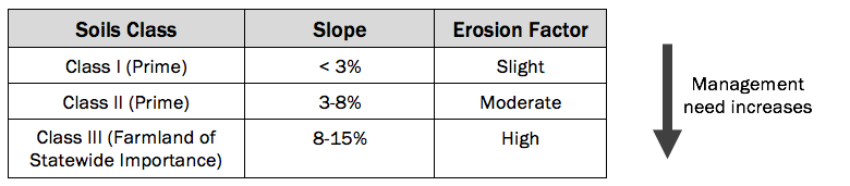
Prime Farmland
The Natural Resources Conservation Service defines prime farmland as follows:
“Land that has the best combination of physical and chemical characteristics for producing food, feed, forage, fiber, and oilseed crops and is also available for these uses. It has the soil quality, growing season, and moisture supply needed to produce economically sustained high yields of crops when treated and managed according to acceptable farming methods, including water management. In general, prime farmlands have an adequate and dependable water supply from precipitation or irrigation, a favorable temperature and growing season, acceptable acidity or alkalinity, acceptable salt and sodium content, and few or no rocks. They are permeable to water and air. Prime farmlands are not excessively erodible or saturated with water for a long period of time, and they either do not flood frequently or are protected from flooding.”
Prime farmland is valuable because there are few limitations to cultivation. Unfortunately, many of the characteristics of the best-quality farmland are also favorable for development (flat topography, well-drained, low flood risk, etc.).
A map of prime farmland can help St. Louis County prioritize conservation areas. Alternatively, elevation contours and soil hydrology/wetland characteristics give a good indication of agricultural value. These features are considered in the pre-application process to development.
Table 3.1 – Prime Farmland Summary
Farming and Forestry Tradition
Direct employment in Farming and Forestry is less than 200 workers, according to the Bureau of Labor Statistics (BLS). However, the BLS does not account for landowners who lease their field or forest for production. Those landowners’ livelihoods are tied to farming and forestry, even though they aren’t farmers or loggers, per se. Further, the Bureau of Labor Statistics reports only on workers’ primary source of income, and some agricultural workers and foresters have other jobs. Overall, farming and forestry are an integral part of St. Louis County’s land heritage and its modern economy. The importance of these industries to St. Louis County is understated by the BLS classification system.
Renewable Energy
With improved technology and increased investment, renewable energy alternatives are expanding globally. Among the states, Minnesota has set one of the strongest renewable energy standards. Utilities are required to provide 25 percent of electricity generation from renewables by 2025. Private industry has responded. For example, Great River Energy met the 25 percent goal in 2017, and is pushing for 40 percent by 2025. With strong clusters in production technology and electric power, St. Louis County may be able to capitalize on industry growth.
Among renewables, wind and solar are Minnesota’s primary focus. Note that increasing rates of electricity consumption from wind and solar could imply a more decentralized system of energy production and distribution in Minnesota’s future. Therefore, expanding local capacity in St. Louis County is a practical goal for long-term resilience. This has direct implications for land use planning and zoning. One short-term action to support opportunities for wind and solar is to review the zoning ordinance, and amend it as necessary to provide for utility-scale systems.
Solar energy systems and wind turbines require favorable climate characteristics to justify the cost of investment. Minnesota’s Solar Suitability Application is a useful tool for identifying the best locations for solar. Overall solar suitability is limited by land cover (large areas of forests and wetlands), but pockets of open space have potential. There is also opportunity to reclaim closed mines or landfills for this purpose.
Solar Partnership
Partnering with Minnesota Power and University of Minnesota-Duluth, St. Louis County installed three 10,000-watt solar systems on the roof of its Government Services Center (GSC) in 2013, as part of a study aimed at evaluating the performance of various photovoltaic systems in the northern Minnesota climate. Public-private partnerships such as this may lead to further opportunities to deploy alternative energy technologies and create new jobs in St. Louis County.
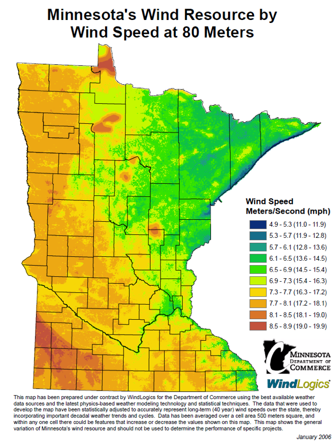
Compared to the rest of Minnesota, St. Louis County has low potential for broad development of wind energy systems (Figure 2.5). Tall turbines would be needed to generate wind energy at a large scale. Moving forward, St. Louis County will probably benefit from wind power generated in western Minnesota and North Dakota, through its primary utility agreement. Note that a large increase in consumption of renewable-powered electricity could require modifications to the electrical grid and energy storage systems (i.e., batteries), regardless of where the electricity is produced.
Infrastructure
Infrastructure, like energy, plays a critical role in powering the local economy. St. Louis County has historically benefitted from a strong freight system, including highways, railroads, and the Port of Duluth. In addition to transportation infrastructure, utilities and services like broadband internet are essential for economic growth and development.
Figure 2.5 – Minnesota Wind Speed at 80 meters
Internet access
Access to internet through direct broadband links and wireless connections can be a significant factor in attracting business and industry to St. Louis County. Broadband service objectives are twofold: 1) increasing overall access to service networks, and 2) increasing the capacity (speed) of service. Increasing the speed and coverage of broadband services can help businesses expand to new locations in St. Louis County, and help businesses increase their productivity and efficiency. This is increasingly true for in-home businesses.
The state’s broadband target for 2022 is 25 megabits per second (mbps), increasing to 100 mbps by 2026. In 2017, 82 percent of the county’s residents had access to 25 mpbs of broadband, while 39 percent of the county’s residents had access to 100 mpbs.
High-speed internet requires fiber optic cables. Increasingly, fiber lines are standard with new development. Typically, developers finance the installation of main lines within the easement, and homeowners/businesses have the option to connect to the lines and/or utilize a wireless connection. The high-speed potential of fiber optics provides flexibility for individual companies and residents to select the service speed that meets their needs/budget.
St. Louis County will use the following strategies to increase internet service capacity:
- Encourage development in locations that are already served by, or which can reasonably be served by, high-speed internet.
- Encourage access to fiber cables for all developments.
- Match service capacity to user needs.
- Coordinate with local providers to improve internet service maps.
- Encourage internet service agreements prior to approval of the preliminary plat. This ensures that cable installation is financed by the developer.
- Promote the “dig once” concept (parallel installation of roads and utilities).
- Expand wireless options for areas which cannot be physically connected to the broadband network.
- Identify ideal sites for telecom towers to ensure fiber connectivity and widespread service area coverage, while minimizing visual impacts and other nuisances.
- Encourage building/internet sharing arrangements where capacity exists.
- Plan for mutually supportive broadband facilities between St. Louis County, townships, and cities.
Opportunity Zones
In 2017, Congress enabled the creation of Opportunity Zones, a new community development program that utilizes tax credits to encourage investments in low-income communities. There are three Opportunity Zones in St. Louis County, three in Duluth, and one on Bois Forte Reservation. Within these zones, certain properties may be eligible for preferential tax treatment. County efforts to support local cities and coordinate with regional tribes as detailed in this Plan will be important in encouraging investment in designated Opportunity Zones. The county will work with local entities responsible in designated Opportunity Zones to further local reinvestment and revitalization efforts.
Economic Development Goals, Objectives, & Implementation
Goal ED-1: Leverage locational advantages to develop economic strengths.
Objectives
ED-1.1: Develop new industries or clusters of related industries which support and strengthen local assets. Broaden the industrial base by supporting marketing efforts for value-added industries that “spin-off” from existing industries.
ED-1.2: Encourage expansion of sustainable timber production.
Goal ED-2: Improve the resilience of regional industries.
Objectives
ED-2.1: Recognize and ensure regulatory fairness across a thriving lodging industry that includes hotels, bed and breakfasts, and vacation rentals.
ED-2.2: Align hazard mitigation planning with comprehensive planning efforts and economic development strategies.
Goal ED-3: Increase high-speed network service, access to the latest related technologies, and associated economic development opportunities.
Objectives
ED-3.1: Promote high-speed telecommunications network expansion in the locations where the service is needed. Work with local stakeholders to prioritize areas for service expansion.
ED-3.2: Work with utility providers and local, regional, and state government agencies to promote the availability of high-speed network access and the corresponding opportunity to work remotely in unincorporated areas.
ED-3.3: Develop county policies and partnerships to creatively include high-speed network infrastructure in plans for economically-efficient road and other utility and infrastructure system projects.
Goal ED-4: Develop skills of local workforce.
Objective
ED-4.1: Encourage local workforce training programs and continuing education to match local workforce with workforce demand.
Goal ED-5: Ensure that the county’s land use regulation system serves to enhance county economic development strategies.
Objectives
ED-5.1: The county will coordinate with state and regional development groups to leverage the Future Land Use Map as an economic development tool.
Goal ED-6: Take advantage of opportunities to expand renewable energy resources.
Objectives
ED-6.1: Encourage utilities to develop utility-scale solar, wind, and biomass facilities in Forest and Agriculture areas designated on the future land use map, as long as facilities are carefully sited to avoid impacts to future mining opportunities, sensitive habitats, and other environmentally-constrained areas.
ED-6.2: Encourage onsite (placed on buildings or free-standing) solar and wind power use on residential, commercial, and industrial properties.
Goal ED-7: St. Louis County will work with natural resource-based industries, such as mining and logging, to practice environmentally responsible extraction and forestry management and to better anticipate impacts on other land uses.
Objectives
ED-7.1: The County Planning and Community Development Department and Land and Minerals will increase its engagement with mining operators in areas of exploration and siting, expansion proposals, closures, and mitigation.
ED-7.2: The County Planning and Community Development Department will increase its engagement with logging operators in areas of proposed timber sales and reforestation.
Goal ED-8: Leverage the availability of county tax forfeit lands to the county’s advantage.
Objectives
ED-8.1: Take advantage of opportunities to preserve tax forfeit land under county management for future regional trail connections.
ED-8.2: Review tax forfeit land adjacent to developed areas to assess the potential to market such property for its highest use.
ED-8.3: Review tax forfeit land within highly sensitive environmental areas, and work to market such property to federal, state, and nonprofit entities for long-term protection.
ED-8.4: Improve collaboration between county departments and necessary local, regional, and state agencies to manage and market tax forfeit properties in line with the goals and objectives of the County Comprehensive Land Use Plan.
Implementation

About
Learn more about the St. Louis County Comprehensive Land Use Plan.
Appendices
View report appendices.
Contact
Contact us with questions or for more information.
County Land Explorer
Visit St. Louis County's GIS website. You will be redirected to the site in a new window.