Natural Environment
Introduction
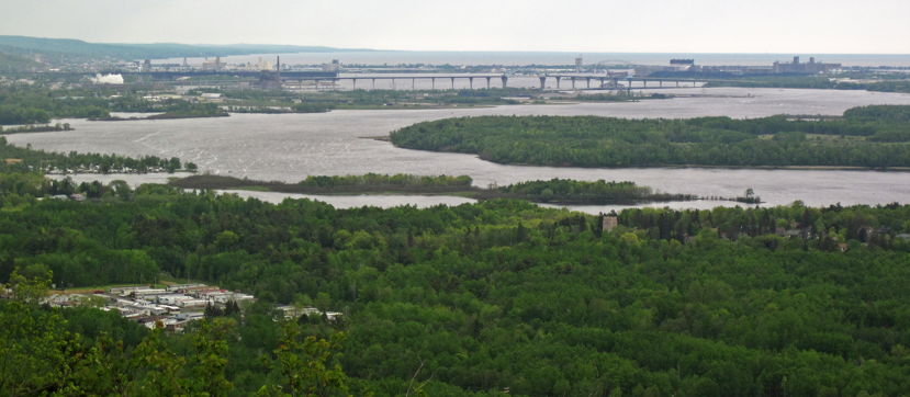
St. Louis County’s rich and diverse natural environment largely defines the character of the county. Over the centuries, Native Americans, European settlers, current residents, and visitors have relied on and enjoyed the benefits of the county’s forests, minerals, waters, and wildlife. This in turn has created a vibrant tourism industry, largely dependent on these natural areas.
Planning for healthy and sustainable communities requires taking into account the natural environment. Fundamental to this planning approach is knowing the location and condition of natural areas and providing appropriate guidance in the Plan to help protect valuable natural assets. Key focus areas related to the natural environment of the county include:
- Forests and related lands
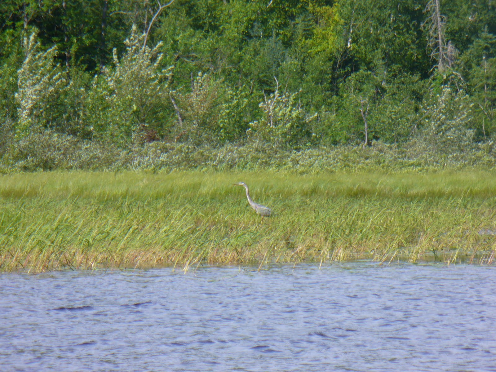
- Fish, wildlife, and wild plants
- Water quality
- Water supply
- Sensitive habitat and rare species areas
- Tourism locales
The Plan is an important, proactive tool that will enable the county to address how growth and change will occur in a sustainable fashion.
Ecosystem Services
In addition to the obvious and known value of the natural environment, there are many unseen yet positive benefits of natural resource conservation that support individuals and communities. For example, compared to developed landscapes, forests and other naturally vegetated areas are better at cleaning air and water and regenerating plant and animal life.
The natural environment provides many valuable ecosystem services, including direct goods (food, forage, fiber, etc.), supporting services, and regulating processes. The Millennium Ecosystem Assessment of 2005 provides a global assessment of these ecosystem services. Table 1.1 lists example ecosystem services in St. Louis County:
Table 1.1 – Example Ecosystem Services
| Supporting (Natural Processes) | Provisioning (Goods) | Regulating |
| Nutrient cycling (carbon, phosphorus, etc.) | Clean air | Climate stabilization |
| Carbon sequestration in plants & soil | Fertile and productive soil | Water volume and flow regulation |
| Groundwater recharge | Fresh, clean water | Flood and drought regulation |
| Pollination of crops and wild plants | Fuel production (biomass for energy) | Disease and pest control |
Natural environment assets can define how a community sees itself, with far-reaching effects on culture and the economy. They add real value, both in their mere existence and their usefulness. This in turn creates a sense of place that attracts and retains new residents and businesses. They can also be the reason that people visit and recreate in St. Louis County. Raising awareness of how natural assets positively affect the culture and economy of the county will lay out the reasons to protect and manage the natural environment.
County Natural Environment and Land Use Issues
Many issues affect St. Louis County’s natural environment. The following sections describe current trends and issues, particularly those that affect the county’s extensive forest lands and water resources.
Land Ownership and Land Use Issues
Forestland Ownership
The vast acreages of St. Louis County’s upland and wetland forests include large public forest land bases managed by the U.S. Forest Service, Minnesota Department of Natural Resources, and the county Land and Minerals Department. The county Land and Minerals Department manages a state tax-forfeited land base of just under 900,000 acres, of which roughly two-thirds is considered commercial forestland. The county’s tax-forfeited land base is owned by the state but managed in trust by the county. The majority of the county’s state tax-forfeited land base is classified to be retained for forest and land management. Those lands not conducive to the county’s long-term forest management land base are classified for disposal through sale, conveyance or exchange.
Refer to the Land Use Goals, Objectives, & Implementation section for more information regarding tax-forfeited lands classified for disposal.
Decrease in Non-Industrial Private Forest Lands
Minnesota’s private forest industry continues to divest its private land holdings through private sale and larger land sales to real estate investment trusts and timberland investment management organizations. Non-industrial private forest lands were traditionally open to the public for activities like hunting, hiking and other recreational activities. These lands were traditionally managed for forest products and kept in large forested land holdings. A portion of non-industrial private forest lands now are being leased to hunting groups or sold, resulting in a decrease of forest lands historically available to the public. Potlatch Corporation land is being offered for sale in smaller acreages to The Conservation Fund, which has exchanged or sold the land to government agencies and conservation groups.
Public comment received during development of the Plan reflected the concerns of hunters and trappers over the decreasing availability of lands for hunting and trapping, partly as a result of the decrease in non-industrial private forest lands. The Future Land Use Maps reflect a sensitivity to this issue by designating over 95 percent of land under county jurisdiction as Forestry and Agriculture or Natural Areas. Both of these land use categories aim to limit development and subdivision of larger parcels that are more appropriate for agriculture, forestry, and the protection of the natural environment – these areas are more conducive to hunting, trapping, and outdoor recreation.
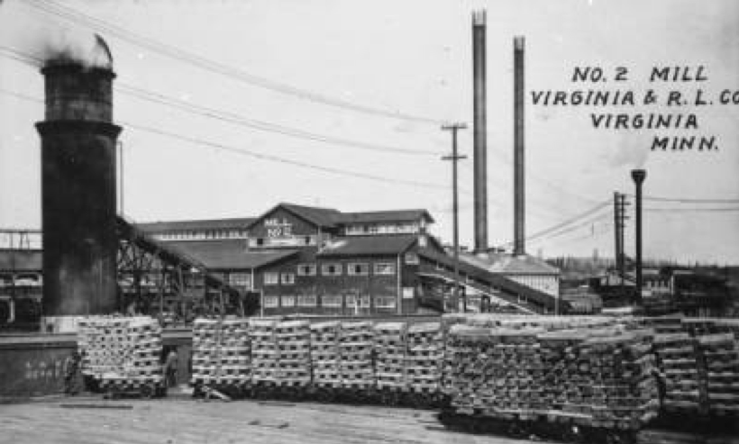
Loss of Timber Mills
The loss of timber mills has resulted in a surplus of certain forest products in northeast Minnesota. Pine pulp, balsam fir and woody biomass markets have weakened over recent years, resulting in over supply of these products available in the county. Demand for other forest products including aspen, spruce and pine bolt material remain in strong demand from the existing paper and lumber mills in the state. Over the last 10-12 years, several wood products mills have shut down or decreased production. This has resulted in decreased consumption of woody biomass. However, some mills in the region have increased production or diversified products.
The County Comprehensive Land Use Plan has identified the opportunity for new timber mills (and related businesses) to locate in the county. The Future Land Use Map has identified several potential industrial sites with freight access (rail and/or major highway access) to attract this type of business to the county. The Natural Environment Goals, Objectives, & Implementation section includes actionable language regarding this issue.
Increased Fuel Loading
Previously, timber harvesters were able to utilize balsam fir and undersized woody material and slash to supply strong balsam and biomass markets. However, decrease in these markets has resulted in more of this material remaining in the forest, which has increased fuel load and potential for wildfire in some areas.
Public comment received in development of the County Comprehensive Land Use Plan reflected concerns related to fuel loading throughout the county, especially in lakeshore development areas. The Natural Environment Goals, Objectives, & Implementation section includes actionable language regarding this issue.
Parcelization
Parcelization, the subdivision of large land holdings into smaller ownership parcels, is a national trend that has been occurring for many decades in northern Minnesota. In St. Louis County, parcelization typically involves sale of non-industrial private forest lands. The Conservation Fund has been working with Potlatch to address concerns of parcelization.
Expansion of Mining
Demand for ferrous and nonferrous metals has led to the expansion of mining operations and initiatives in St. Louis County. While these mines can provide needed jobs in the county, they may also come with environmental impacts and risks, which require mitigation, subsequent reclamation, and significant financial assurances.
Expansion of Wetland Mitigation
Anticipated wetland impacts associated with proposed mine expansions have prompted an increase in large-scale wetland mitigation projects in the county. This is exemplified in the Lake Superior Mitigation Bank, which has initiated the restoration and enhancement of over 23,000 acres of wetland in the county.
Water Resource and Land Use Issues
Impaired Waters
Many of St. Louis County’s surface waters are impaired for their designated uses. The most common impairment is mercury in fish tissue, which is caused by atmospheric deposition of mercury, largely from coal-fired power plants to the west. Other impairments to county waters include mercury in the water column, poor aquatic biodiversity, nutrient enrichment/eutrophication, turbidity, suspended solids, E. coli bacteria, low dissolved oxygen levels, and other contaminants in fish tissue or the water column. This Plan includes actionable language that addresses wastewater issues related to failing septic systems and the protection of lakes and watercourses through setbacks/buffering. Note that impairments stemming from septic systems are minor compared to other sources of pollution.
Aquatic Invasive Species (AIS)
AIS is a growing concern in St. Louis County. Invasive aquatic plants and animals harm water resources, and control of these species is very challenging due to the connectivity of waters and mobility of vectors. For more information on the county’s efforts to control AIS, refer to the St. Louis County Aquatic Invasive Species Prevention Plan.
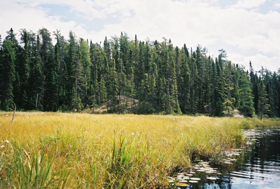
Lakeshore Development
St. Louis County’s rich assemblage of northland lakes makes the region very attractive to lakeshore development. Lakeshores are biodiverse and productive features in the landscape; therefore, development in these areas should be done carefully to protect these sensitive areas and the adjacent water resources. St. Louis County has adopted Minnesota Department of Natural Resources shoreland standards. Additionally, the county also has “Shore Setback and Shore Impact Zone Requirements” and special protections for trout streams, which are common along Lake Superior’s north shore and are scattered throughout the remainder of the county.
The Future Land Use Maps aim to further the protection of many lakes and trout streams in the county through the application of the Natural Areas future land use category. The Natural Areas future land use category includes a 150-foot buffer around the shoreline of all “Natural Environment” lakes as designated by the Minnesota Department of Natural Resources. Also, the Natural Areas future land use category includes a 150-foot buffer around all county trout stream centerlines.
Related Plans and Studies
St. Louis County recognizes the many entities that have recently completed natural resources-related plans within the region. A synopsis of these plans is given below.
Northeast Landscape Forest Resources Plan
The Northeast Landscape Forest Resources Plan was prepared by the Minnesota Forest Resources Council. Aspects of this plan – including collaboration with other agencies, sustainably managing vegetation, protecting water and wildlife habitat, and providing forest products, recreation, and minerals – are central to county management of tax-forfeited lands. The St. Louis County Land and Minerals Department contributed to the development of the plan.
The issue of harvesting forest products from tax forfeit lands while sustaining other values of the forest is being addressed by the county Land and Minerals Department through its own policies and practices, consistent with the Northeast Landscape Forest Resources Plan. These policies and practices are supported by this County Comprehensive Land Use Plan.
Comprehensive Water Management Plan
The Comprehensive Water Management Plan was prepared by the St. Louis County Planning and Community Development Department and the St. Louis Soil and Water Conservation Districts. The plan provides strategies to address water-related issues in the county, many of which are linked to county land use practices. For this reason, the County Comprehensive Land Use Plan, through its goals, objectives, and implementation actions, includes actionable language to help in addressing these issues.
St. Louis River Watershed Restoration and Protection Strategy Report
The St. Louis River Watershed Restoration and Protection Strategy Report was prepared by the Minnesota Pollution Control Agency. Using a state-adopted watershed approach, this Water Restoration and Protection Strategy (WRAPS) report characterized the St. Louis River watershed, assessed whether waters are meeting safe-use standards and providing beneficial uses, identified impairments in the watershed, identified restoration and protection strategies, and provided recommendations for next steps and progress assessment. Encouragingly, the report states that there are many opportunities for conservation easement purchase, and significant amounts of county-, state-, and federal-owned lands that can be used to protect surface and ground water. Actionable language in this County Comprehensive Land Use Plan will help to protect the St. Louis River watershed consistent with the aims of the MPCA’s watershed strategy report.
St. Louis County Aquatic Invasive Species Prevention Plan
The Aquatic Invasive Species Prevention Plan was prepared by St. Louis County to mitigate the impacts of aquatic invasive species (AIS) that threaten Minnesota waters. These non-native species harm natural resources, fishing and cultural heritage, industries, agribusiness, recreation, and the economy. By addressing pathways through which AIS are spread, the Aquatic Invasive Species Prevention Plan is a critical tool for protecting the natural environment and resource-based industries.
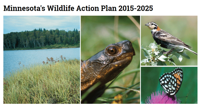
Minnesota Wildlife Action Plan and Wildlife Action Network
Minnesota’s Wildlife Action Plan was prepared by the Minnesota Department of Natural Resources. Minnesota is home to over 2,000 known native wildlife species. Approximately 16 percent (346 species) are identified as Species in Greatest Conservation Need (SGCN) because they are rare, their populations are declining, or they face serious threats that may cause them to decline.
The Wildlife Action Network (WAN) was developed as part of the 2015-2025 Wildlife Action Plan revision. The WAN uses state-wide Geographic Information Systems (GIS) data layers to assess the quality and importance of aquatic and terrestrial habitats for SGCN. WAN mapping was used to develop the Natural Areas Framework, Natural Environment Gap Analysis, and Future Land Use Map of St. Louis County, discussed later in this document and in the Land Use Report.
Elk Reintroduction Study
This study was prepared by the University of Minnesota. Elk historically occupied most of Minnesota prior to the early 1900s, and there has been interest in restoring elk to northeastern Minnesota. The study will help determine if and how an elk reintroduction program would proceed in St. Louis County.
Natural Areas Framework
The county’s natural areas and nature-based destinations were compiled, analyzed, and summarized in a Natural Areas Framework (Figure 1.1 and Table 1.2). The methodology for developing this framework is described in the Land Use Report, and the protection issues described in Table 1.2 are discussed in the following Gap Analysis section of this Plan.
Figure 1.1 – Natural Areas Framework Map
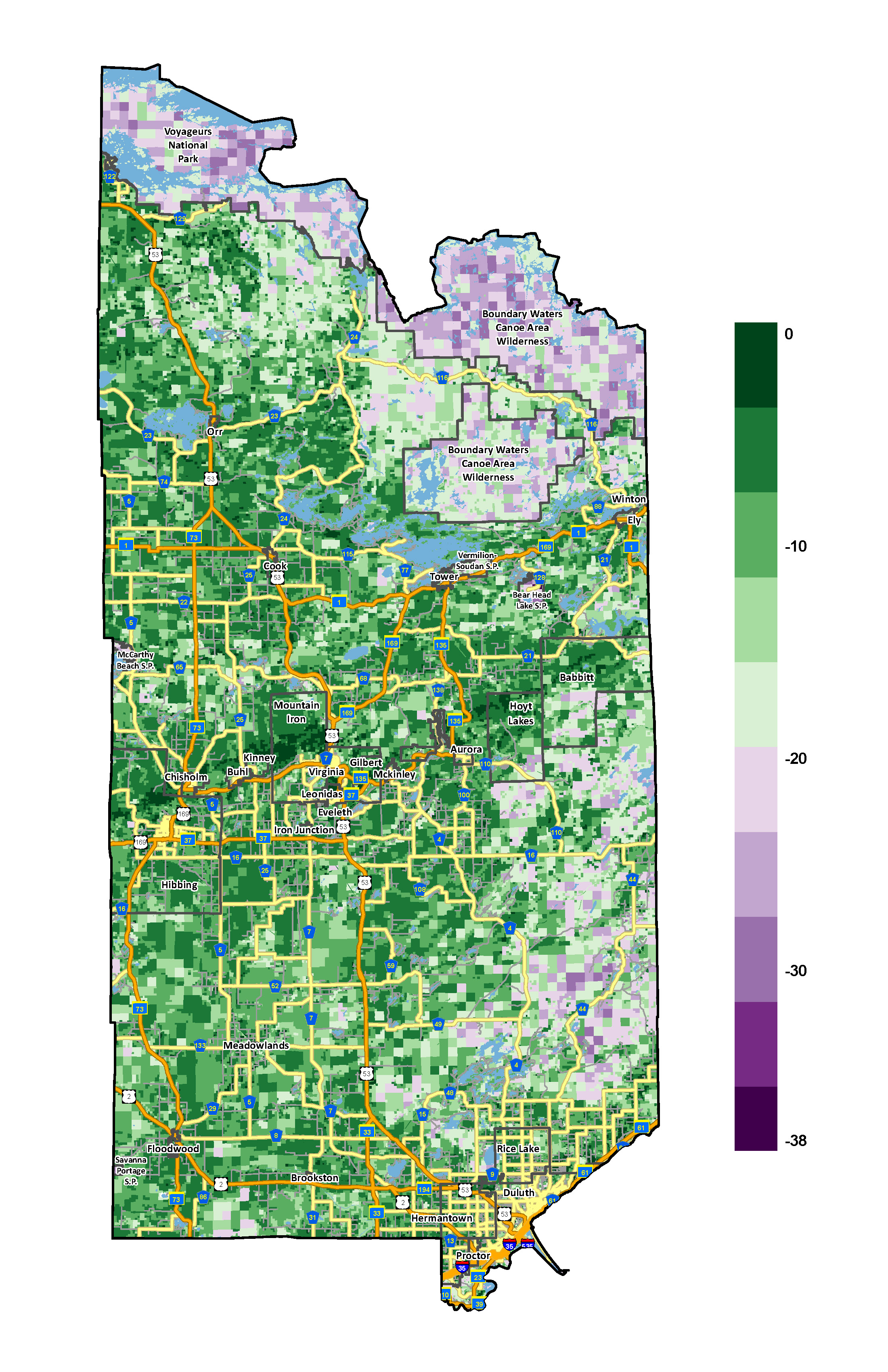
Table 1.2. – Natural Areas Framework Features
Gap Analysis
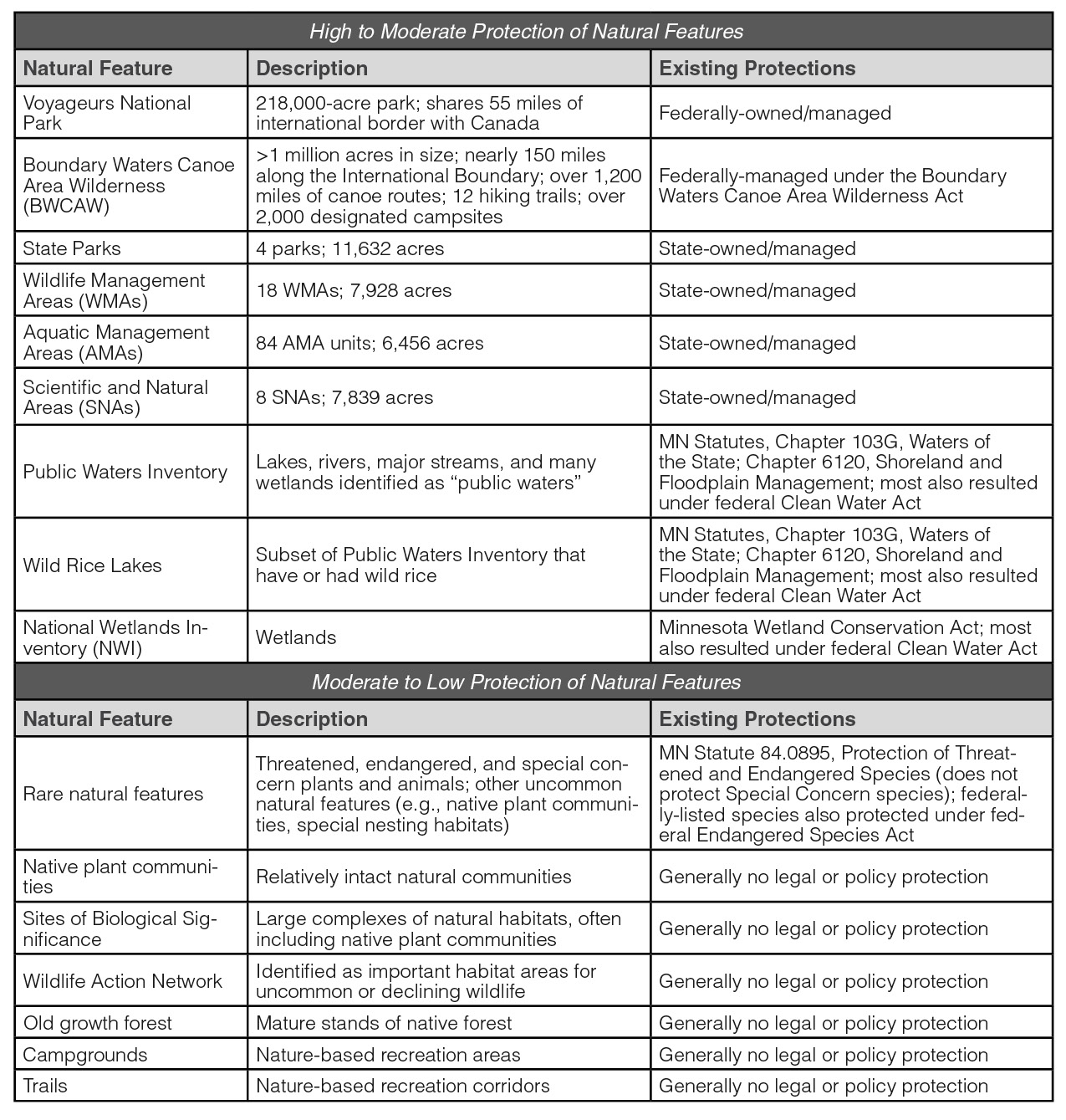
 Many existing federal and state regulations protect the natural environment. However, St. Louis County wants to ensure that valued county natural assets are recognized, and when feasible, protected for the many public benefits they provide – now and long into the future. To achieve this goal, a natural environment “gap analysis” was conducted of the county’s natural features. For this Plan, the approach was to map higher-quality natural areas and features that may warrant conservation, and then “erase” those natural areas with existing legal protection. This process reveals valued natural assets that may lack protection. Table 1.2 lists the higher-quality natural features used in the analysis; these are essentially the same datasets used in the Natural Areas Framework, discussed above and in more detail in the Land Use Report. The table also presents some of the existing protections (e.g., ownership, regulations) for these features.
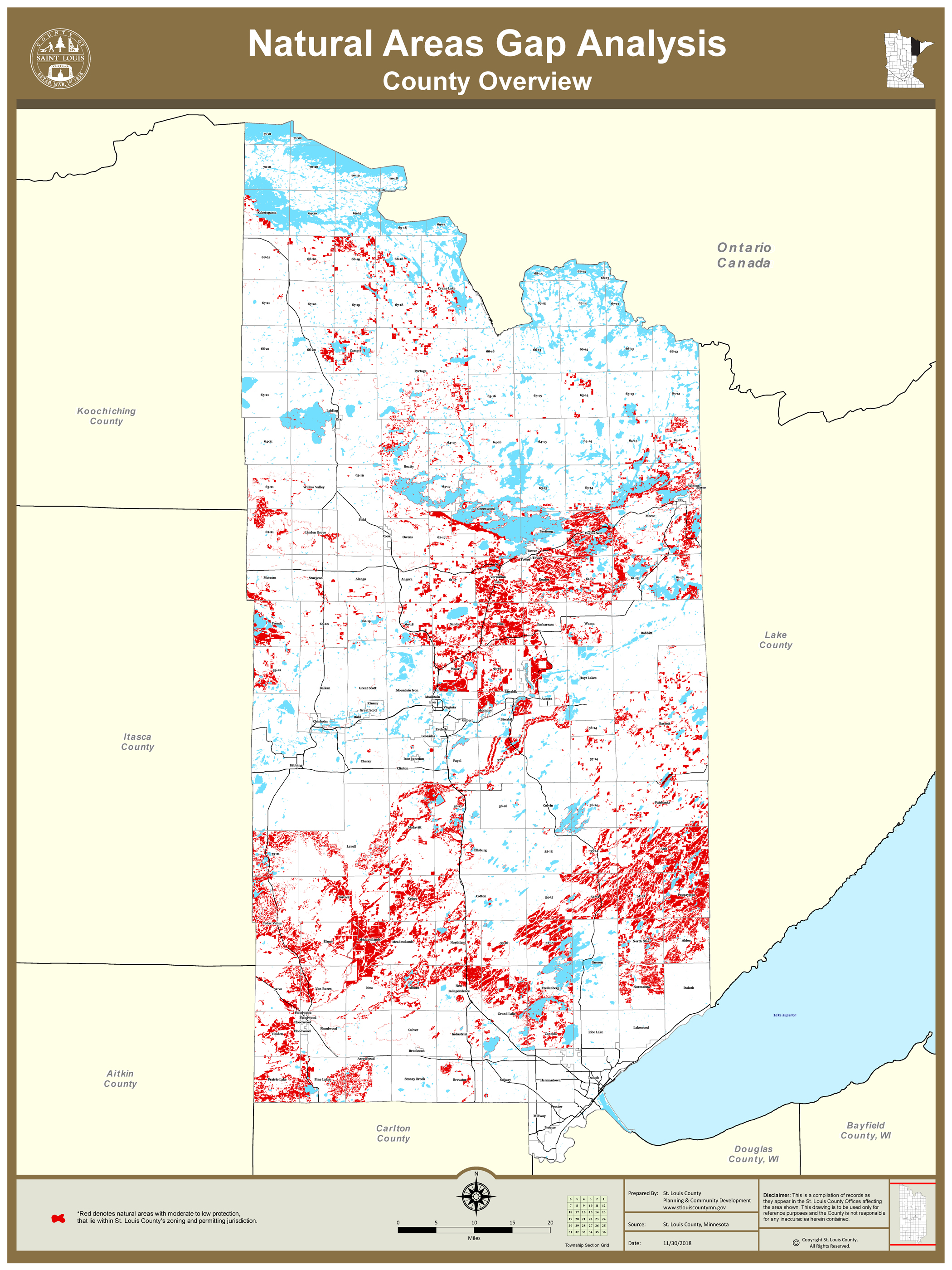
The natural features gap analysis was conducted using GIS, a computer-based mapping system. Natural features identified in Table 1.2 as having “High to Moderate Protection” are displayed in white, erasing the natural features that are generally protected by existing land ownership, policy or regulations. The remaining natural features identified as having “Moderate to Low Protection” were indicated in red; these natural features generally lack protection (Figure 1.2).
Gaps in the protection of the county’s important environmental assets exist. The less protected natural assets (red) in Figure 1.2 are mostly Wildlife Action Network habitats, many of which overlap with Native Plant Communities and Sites of Biological Significance.
Figure 2.2 – Natural Areas Gap Analysis Map
Informational Tool for the Development Review Process
The county will use the gap analysis to identify opportunities to increase protection of natural resources during review of public development proposals, zoning and subdivision applications, and in other situations when land use comes under county purview. When unprotected natural features exist within a proposed planning or development area, greater scrutiny will be exercised by county staff to determine what actions may be taken to protect natural features.
Sequencing Strategy
One practice commonly used to protect natural features is called “sequencing,” whereby impacts to natural features are first avoided to the extent possible, then unavoidable impacts are minimized, and finally all impacts are mitigated (e.g., replaced elsewhere). This type of sequencing will be adopted as part of the county’s planning and development review procedures, and is incorporated in this plan’s implementation actions.
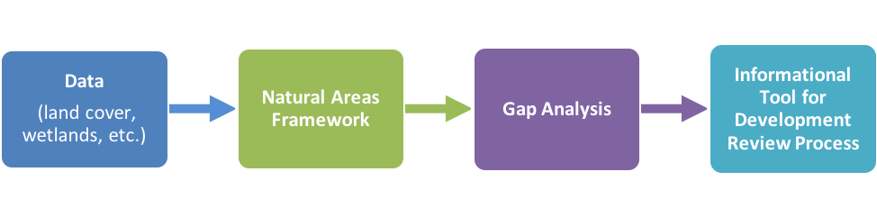
The flow chart below shows how data related to St. Louis County’s natural environment was utilized to create the Natural Areas Framework, which was refined to create the Gap Analysis, ultimately resulting in a tool for county staff to assess how proposed development might impact the natural environment.
Conservation Tools & Partnerships
There are a variety of mechanisms and programs that exist or could be employed to help St. Louis County achieve its goals for the natural environment. Some examples follow.
Conservation Design
The Natural Areas Framework and Gap Analysis lay the groundwork for county planners to identify opportunities to protect, connect, and buffer valuable and sensitive natural areas and corridors.
Each development offers opportunities to implement conservation design. The county has design standards for conservation subdivisions (Subdivision Ordinance). These standards provide good, basic practices for more environmentally sensitive residential development. However, there are many opportunities to expand this section to provide more environmental benefits for natural resources and county communities. For example, these conservation design practices could be applied to commercial and mixed use developments as well.
The county can encourage these practices by providing incentives to developers to follow conservation design standards, or the county may choose to make such standards mandatory for development within targeted areas that would most benefit from a more careful, environmentally-sensitive approach to development. Such areas could include Wildlife Action Network habitats, watersheds and groundwater recharge zones of trout streams, steep slopes, natural environment lakes, etc.
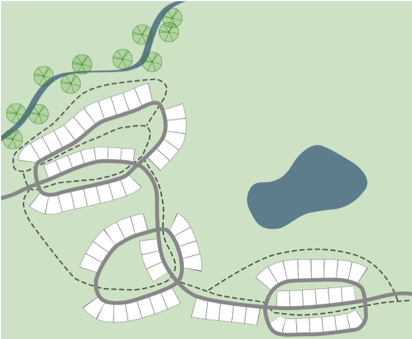
This “checkerboard” plat apportions all land to private owners, including the wooded stream corridor and pond (parcelization).
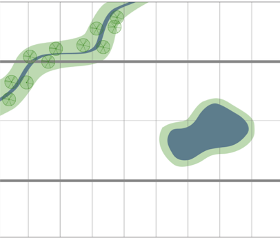
This design accommodates more lots, avoids parcelization of the main natural features, and conserves a large open space network accessible by trails. This design approach also facilitates extension of urban services, which makes it appropriate for developing areas.
Land Trusts
The Minnesota Land Trust is currently involved with the county in the purchasing of tax-forfeited lands. A multi-year effort is underway between the Minnesota Department of Natural Resources (DNR), the Minnesota Office of School Trust Lands, the U.S. Forest Service and The Conservation Fund that will significantly expand revenue for Minnesota’s 337 public school districts and eliminate the patchwork ownership within the Boundary Waters Canoe Area Wilderness (BWCAW).
Conservation Easements
Conservation easements are a commonly used strategy to protect natural areas without transfer of property ownership. Conservation easements could be established on county-owned lands identified as Sensitive Areas and along county trails. Additionally, the county may choose to require that all conservation developments include conservation easements that address the site’s natural open space.
Goal NE-1: Strive for local decision-making that balances social, economic, and environmental concerns.
Objectives
NE-1.1: County policies and approvals related to land use, development, and management will be made to address current needs without compromising the ability to meet future needs.
NE-1.2: County operations, land use, and management will be refined to be more efficient and environmentally-responsible.
Goal NE-2: Water resources in the county (surface and ground waters) will be protected, while allowing for development and use of natural resources that properly mitigate for impacts to water resources.
Objectives
NE-2.1: County policies will protect surface waters and groundwater resources.
Goal NE-3: St. Louis County will promote the responsible stewardship and efficient use of natural resources.
Objectives
NE-3.1: The county, working with partners, will increase public education and engagement regarding the stewardship, conservation, and efficient use of natural resources.
NE-3.2: Expand targeted partnerships to effectively advance county natural resources goals and to better manage sensitive natural areas.
Implementation

About
Learn more about the St. Louis County Comprehensive Land Use Plan.
Appendices
View report appendices.
Contact
Contact us with questions or for more information.
County Land Explorer
Visit St. Louis County's GIS website. You will be redirected to the site in a new window.