
Transportation
Transportation Relationship to Land Use and Economy
Transportation, land use, and economy are interrelated. Roadway system characteristics impact the use of adjacent land, land value, and subdivision design. St. Louis County’s system of highways and railroads is the connective tissue that supports the regional economy. Because of these relationships, it is important to emphasize consistency between land use planning, transportation plans, and economic development plans. The county’s capital improvement plan (CIP), for instance, is guided in part by land use and economic priorities, which have been formally adopted by the Board of Commissioners. These priorities include:
- Expanding the tax base in a way that will benefit the health and well-being of county citizens
- Managing and encouraging orderly growth in coordination with other units of government and the private sector to promote a healthy economy
- Maintain and improving a healthy, viable ecosystem and the community’s quality of life
County Responsibilities
The St. Louis County Public Works Department is responsible for maintaining roads within county jurisdiction, including County Roads and County State-Aid Highways (CSAH). St. Louis County provides limited assistance to rural townships. Note that the county is not obligated to maintain local township or community roads.
Transportation investments are guided by the Capital Improvements Plan (CIP) and Transportation Improvement Plan (TIP). The CIP is financed through the County General Fund. The TIP is developed with MnDOT, and financed through the Greater Minnesota Transportation Sales and Use Tax. The TIP includes highway projects, gravel road improvements, safety projects, and multimodal projects, including Safe Routes to School.
Plan Coordination
Transportation planning often entails inter-jurisdictional coordination. The County Public Works Department is a primary stakeholder or leading agency in many intergovernmental projects and programs, frequently coordinating with MnDOT District 1 and local communities. Examples of collaborative opportunities include:
- County-wide Road Safety Plan (MnDOT)
- Tribal transportation plans (tribes, MnDOT)
- State/regional freight plans (MnDOT)
- Safe Routes to School Program (local communities)
The county is open to developing partnerships to finance planning, engineering, and construction of projects within its jurisdiction.
Subdivision Standards
St. Louis County Public Works has established minimum standards for design and construction of public roads, which are necessary to ensure safe, efficient travel operations. These standards are codified in the Subdivision Ordinance. Dimensional requirements for right-of-way, easements, and other features must be observed on subdivision plats. The regulations are required for all County Roads, and are strongly encouraged for private roads and local township roads.
The St. Louis County Planning and Community Development Department reviews all subdivision plats within its jurisdiction. St. Louis County Public Works is a key partner in this review, determining whether roadway requirements are met. Further coordination occurs as needed – for example, when a proposal requires a traffic impact study.
Note that MnDOT must review all development applications which involve the creation or modification of an access to the trunk highway system. When MnDOT review is required, coordination should take place in the pre-application stage of development planning.
Access Management
Access management ensures the roadway system functions safely by controlling the spacing between intersections and driveways. Because most County Roads and CSAH roads are low-volume, St. Louis County Public Works evaluates access control on a case-by-case basis. Safety issues can be addressed during platting, re-platting, and road improvements – for example, by consolidating the number of private access points onto a road.
Road System Classification
The roadway network is managed by a hierarchical classification system. The hierarchy of roads includes arterials, collectors, and local roads. Each classification varies in terms of its function, design characteristics, and its relationship to land use.
The Land Use Report discusses roadway classification in detail, and provides maps of roadway jurisdiction (Figure 23) and functional class (Figure 24). Figure 4.1 and Table 4.1 below summarize this classification and the relationship between access and mobility.
Table 4.1 – Hierarchy of Roads
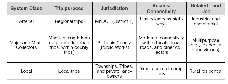
Figure 4.1 – Access/Mobility Relationship
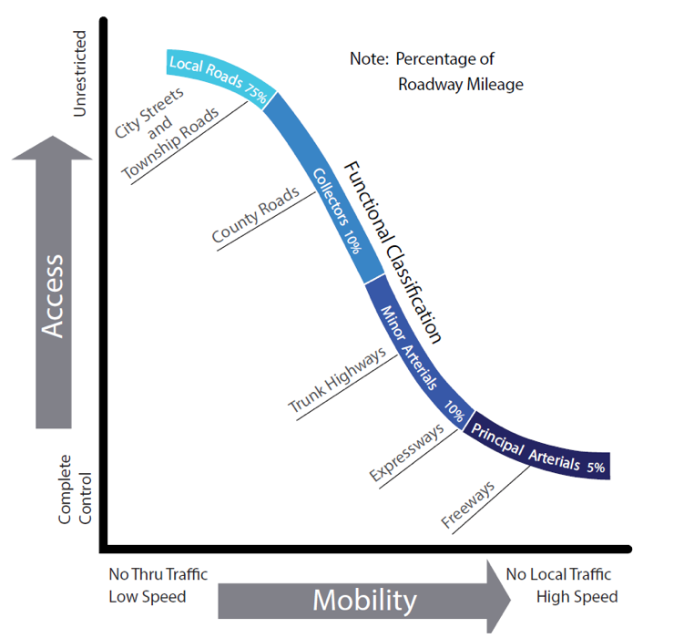
Note that St. Louis County is responsible for the collector system. These roads tend to serve a balance of access and mobility needs, especially in low-density areas.
Road Maintenance
St. Louis County Public Works is tasked with maintaining the largest highway system in the state. This system includes:
- 1,378 miles for County State-Aid Highways (CSAH)
- 1,274 miles for County Roads
- 602 bridges with a span of 10 feet or greater
Maintaining this system involves complex decisions about how and when to conduct maintenance or apply other treatments to keep the roads safe and make efficient use of the county budget. Today, the cost of maintaining transportation systems has become very expensive. With aging infrastructure, rising cost for materials and labor, and stagnant funds, many local governments are re-evaluating the costs and benefits of their maintenance strategy. Some have explored non-traditional strategies and construction methods (e.g., pavement reclamation, conversion of paved surfaces to gravel) to stretch limited budgets. St. Louis County is exploring similar strategies.
Pavement Quality
St. Louis County Public Works monitors pavement quality to assess maintenance needs, using an industry standard pavement quality index (PQI) rating system. The condition of paved roads varies across the county. Overall pavement quality is trending downward. The downward trend of pavement quality is an indication that the county’s fiscal resources may not be sufficient to maintain the existing roadway system in an ideal state or repair over the long term. If there is a long-term funding gap, and the county does not address it, this could impact development opportunities and quality-of-life objectives identified in the County Comprehensive Land Use Plan.
It may be helpful to develop a long-range pavement preservation plan. This plan would identify the gap between known revenues and the cost of improving all roads to their desired level of quality, given assumptions about road design life and traffic loadings. It would identify strategies to reduce the funding gap, such as exploring opportunities for jurisdictional transfers, new revenue sources, and reversion to gravel surface. Such a plan should be consistent with the County Comprehensive Land Use Plan’s objectives for land use and economic development, in terms of directing investments toward corridors with the greatest potential impact (e.g., county freight routes).
See the Land Use Report for further discussion.
Non-motorized Transportation

While on the average St. Louis County is rural in nature, many areas within the unincorporated county create a demand for bicycle and pedestrian activity. This demand is spurred by existing and planned trail infrastructure and the land use characteristics of some of the unincorporated communities. Soudan is a good example of an unincorporated community that involves a higher level of bicycle and pedestrian activity than other more rural areas of the county. Located adjacent to Lake Vermilion State Park, these areas generate a significant amount of pedestrian and bicycle traffic, especially during the summer months.
When road improvement projects are considered, the St. Louis County Public Works Department will coordinate with local communities, townships, and MnDOT District 1 as necessary to review the surrounding land use context to understand existing bicycle and pedestrian needs. In some cases, pedestrian and bicycle facilities may need to be considered in project development to support local community needs and to create a safe environment for bicyclists and pedestrians. Public comment received in the development of this Plan noted that bicyclists and pedestrians are not always the only users that may need to be accommodated. Other users, such as equestrians, may also need to be considered.
Safe Routes to School
 The 2005 transportation bill, SAFETEA-LU, created funding for Safe Routes to School (SRTS), a program designed to increase opportunities for children to walk and bike to school safely. As a participant in the program, MnDOT grants SRTS awards for infrastructure, planning, and implementation activities using a mix of state and federal funds. St. Louis County is the authorizing agency for most communities in the county. It is responsible for sponsoring rural communities (population less than 5,000). The Cities of Duluth, Hibbing, Virginia, and Hermantown are authorized to solicit funds on their own.
Historically, only the larger municipalities have received SRTS funding awards. In 2016-2017, the City of Duluth and the City of Hibbing were awarded funds for implementation and project construction. St. Louis County would like to expand opportunities for other communities to implement the SRTS program. Smaller communities with fewer resources may wish to coordinate with one another to develop a district-wide plan. The county can provide technical assistance, such as data collection and analysis.
Example SRTS infrastructure projects include:
- Filling in the local sidewalk network
- Paved trail/walkway extensions
- Lighting for streets and trails
- Construction of crosswalks
- Traffic calming improvements
Freight
Mining, logging, agriculture, and other essential industries rely on a robust, serviceable freight network. St. Louis County has a strong transportation sector that is connected to virtually every industry.
The county’s primary role is to ensure that county truck routes (County Roads and CSAH) are maintained at the level needed to sustain freight loadings. Also, the county communicates local freight needs and development opportunities with MnDOT, so that trunk highway investments are coordinated with industry needs and development opportunities.
One of the County Comprehensive Land Use Plan’s priorities is Trunk Highway 53 (US 53), from approximately the City of Cook to the Port of Entry at International Falls (Koochiching County). This is an important route for regional and international shipping.
In addition to highways, the freight system includes railroads, airports, and water ports. The county is not involved with the design or operation of these facilities. However, these facilities are encountered from a land use planning perspective – they need to be recognized for potential impacts to development and the surrounding environment, and for any regulations that may affect how adjacent land may be used. For example, airport overlay zones impose restrictions on parcel use and structural size/bulk.
The Land Use Report provides an extended summary of railroads, airports, and water ports that operate in St. Louis County.
Heavy Vehicle Routes
St. Louis County Public Works maintains several maps of spring load restrictions. These maps should be reviewed during pre-applications for heavy industrial development. If possible, development should be guided toward existing freight corridors. Gravel roads have a weight limit of 5 tons per axle and paved roads have a weight limit of 10 tons per axle, unless posted otherwise.
Transit
Arrowhead Transit operates fixed-route bus system and dial-a-ride services in St. Louis County. The bus system services 19 communities in St. Louis County on a scheduled basis, as well as communities in seven neighboring counties. Most communities are served twice a day, in the morning and afternoon, Monday through Friday. The dial-a-ride service operates out of the City of Virginia, providing limited service seven days a week.
Duluth Transit Authority provides bus service to the cities of Duluth, Proctor, and Superior, Wisconsin. This system is the third-largest system by ridership in the state of Minnesota.
Jefferson Lines, a private regional transit company, provides service to Duluth, Hibbing, and Virginia.
Jurisdictional Coordination
A hierarchy of jurisdictional classification is established so that each road is managed by the jurisdiction which is best positioned to maintain the road (Table 4.1). MnDOT is typically responsible for maintaining higher-volume, regional corridors carrying inter-county traffic, while intermediate corridors are maintained by the county, and roadways serving local traffic are typically maintained by municipalities and townships.
Jurisdictional Update
When there is misalignment between highway jurisdiction and roadway management, a jurisdictional transfer can be appropriate. Examples of appropriate times to discuss jurisdictional issues are:
- When a municipality reaches a population of 5,000, and it creates its own municipal state aid system. Growing communities near Duluth may exceed this threshold in the next 20 years.
- When a new roadway segment is constructed that replaces the function of the current roadway.
- During improvements or major rehabilitation of a facility that is a potential transfer candidate.
Concerning transfers to townships, state law requires the county to follow a prescribed process to help township officials accommodate transfers. This process requires a public hearing. In addition, all repairs or improvements must be performed to meet standards of comparable roads, prior to transfer occurring. Finally, the county must continue to maintain the road for a two-year period after the transfer occurs.
Coordination with Tribal Governments
Two tribes occupy reservation lands which are partially contained within St. Louis County. They are the Bois Forte Band of Chippewa and the Fond du Lac Band of Lake Superior Chippewa. Each tribal government maintains an inventory of routes through the Bureau of Indian Affairs (BIA). This inventory primarily consists of low-volume roads and trails. St. Louis County is still responsible for County Roads and the CSAH system within reservation boundaries.
Fond du Lac adopted a 20-year transportation plan in 2016. Bois Forte’s transportation plan dates to 2002. The Transportation Goals, Objectives, & Implementation section includes actionable language for coordinating planning efforts with these tribes.
Funding Opportunities
In response to the challenges described in this chapter, the county adopted a transportation sales and use tax in 2014. This tax is projected to raise $10.5 million annually, which help reduce the funding gap for roadway maintenance. However, the funding picture will fluctuate over the life of this plan, and the county could seek to leverage a variety of potential funding sources and financing arrangements. County staff are familiar with state and federal funding programs and will actively seek a variety of sources to supplement local funds. A summary of traditional and potential funding sources is provided below.
Surface Transportation Program (STP)
The State of Minnesota and large metropolitan areas (i.e., Duluth) use federal STP funds for highway, bridge, transit, pedestrian, and bicycle infrastructure projects. STP covers up to 80 percent of the cost of a project. MnDOT District 1 determines annual disbursements. STP funds may be used on federal aid highways (interstate system), interconnected arterials, and rural major collectors (CSAH system). District 1’s STP allocation is the most predictable funding source for St. Louis County.
State Bonding
The Minnesota Legislature approves a bonding bill, typically every even-numbered year. Occasionally, funds are earmarked for unique local bridge or roadway improvements that have regional or statewide benefit. This source of funding may have potential for TH 53 improvements, which would benefit an intercounty/international trade area. St. Louis County could partner with Koochiching County, regional tribes, and other jurisdiction to lobby for funding.
Local Road Improvement Program (LRIP)
The LRIP is a state program which is funded through general obligation bonds. In 2017, funds exceeded $115 million. Approximately 20 percent of these funds were available for small cities, counties, and townships. Note that only 32 townships solicited funds in 2017, and 25 percent of projects were awarded. This was a much higher success rate than cities and counties. This program could be a good opportunity for local townships in St. Louis County.
Local Bridge Replacement Fund
Bridges that are located on public roads outside the trunk highway system are eligible for bonds from the State Transportation Fund. MnDOT’s Office of State Aid maintains a five-year Master Local Bridge Replacement Priority List. This list is a compilation of county, city, and township needs that have been formally prioritized through a County Board resolution.
Local Option Sales Tax
This is the existing tax that is utilized in St. Louis County. By law, the sales tax must be used for a prescribed list of projects that are approved by the County Board. Funds can be used for local highway preservation and non-preservation work.
County Wheelage Tax
As of 2017, 51 counties in Minnesota had adopted a wheelage tax, allowing them to levy up to $20 per vehicle. This tax could be adopted in conjunction with St. Louis County’s Local Option Sales Tax. The wheelage tax is perceived as a relatively fair tax, since it is structured to assess the vehicle users that it benefits.
Tax Increment Financing (TIF)/Tax Abatement
TIF is used to finance infrastructure improvements (including roads) that are needed immediately. TIF is site-specific, and has little value for county preservation needs, but it can be applicable in special circumstances for certain redevelopment tracts.
Federal Grants
The BUILD Discretionary Grant is the primary federal program for funding general transportation projects, having replaced the TIGER grant program. The U.S. Department of Transportation made $1.5 billion available in 2018. The maximum project award is $25 million. Most county projects would be classified as rural projects, and would not require a local match.
Transportation Goals, Objectives, & Implementation
Goal TR-1: The level of investment in roadway construction, improvement, or maintenance should be aligned with system needs and changes in land use.
Objectives
TR-1.1: Continue to evaluate the costs and benefits of potentially returning some under-utilized paved surfaces to gravel.
TR-1.2: Help the public understand that due to lack of funding, not all township and county right-of-way meets local standards, and in some cases may not be improved at all.
Goal TR-2: The transportation system promotes safety for all users.
Objectives
TR-2.1: Ensure that all land use and related decisions do not impair local efforts to implement the County Roadway Safety Plan.
TR-2.2: Align local and state highway system planning with goals for highway-adjacent land uses.
Goal TR-3: The transportation system serves the accessibility and mobility needs of all users.
Objectives
TR-3.1: Develop the capacity of the highway system in county communities to accommodate pedestrian, bicycle, and paratransit use. Promote transportation alternatives, including paratransit, bicycle, equestrian, and pedestrian facilities, for recreation and for those who are unable or choose not to operate a motor vehicle.
TR-3.2: Continue to support Safe Routes to School improvements for local cities, townships, and unincorporated county communities.
TR-3.3: Continue to support long-range transportation planning performed by County Public Works, the State Department of Transportation, the Arrowhead Regional Development Commission, and the Duluth-Superior Metropolitan Interstate Council.
Goal TR-4: Minimize the negative impacts of infrastructure development on sensitive ecosystems, culturally significant sites, and adjacent land uses.
Objectives
TR-4.1: Utilize benefit-cost analysis to select the best routes and realignments for new highway links and local roadways. Ensure that environmental factors are sufficiently weighted.
TR-4.2: County departments will coordinate to ensure that land use regulatory impacts resulting from road realignments, right-of-way acquisition, and access modifications are properly addressed.
Goal TR-5: Maintain a safe, connected freight system that facilitates shipping and economic development.
Objectives
TR-5.1: Address freight needs when federal, state, and county highways are improved.
TR-5.2: Promote the development and use of the county’s freight system, including a road system that can accommodate heavy truck traffic, the rail system, and port system.
About
Learn more about the St. Louis County Comprehensive Land Use Plan.
Appendices
View report appendices.
Contact
Contact us with questions or for more information.
County Land Explorer
Visit St. Louis County's GIS website. You will be redirected to the site in a new window.