
Public Safety
Introduction
Public health and safety considerations are paramount in planning. These considerations underpin policy at every level of government, from land use planning and permitting activities, to highway safety planning and administration of emergency service operations. The legal basis for zoning lies in government’s responsibility to protect the health, safety, and welfare of all people.
This chapter identifies some of the main threats to public safety, summarizes the role of county agencies in mitigating and responding to these threats, and describes specific ways the County Comprehensive Land Use Plan can support safety goals.
Hazard Mitigation Plan
The 2013 Hazard Mitigation Plan is St. Louis County’s go-to guide for directing public investments and procedures to mitigate the loss of life and property damage resulting from potential disasters. The plan is produced with significant involvement from townships, cities, tribes, and school districts. As such, it is the authoritative guide for developing resiliency at the community level, as well as county-wide. The plan is a requirement for maintaining eligibility for disaster relief funding from the Federal Emergency Management Agency (FEMA).

The Hazard Mitigation Plan describes several natural and man-made threats that could impact St. Louis County in the future. Each threat is assessed for the probability of occurrence. The county is more likely to be impacted by natural threats than by man-made threat. Many threats are inter-related, with the potential to cause cascading effects. Drought and fire are one example.
Fire
Wildfire is one of the greatest hazard threats in St. Louis County, with the county’s substantial forest reserves providing a large source of fuel. In addition to drought, insects and disease compound the risk by the increasing fuel loading for certain tree species. Each fire can pose an immediate threat to public safety. A large fire can threaten air quality, increasing the risk for respiratory illness.
Each year, there are controlled fires, which are an important part of forestry management. The risk of an uncontrolled wildfire outbreak is greatest in the central and northern areas of St. Louis County and at the interface between urban areas and wilderness. In these areas, specifically, it is important for residents to understand what they can do to prevent fire damage, knowing that most wildfires are human-caused, and that fire response times are a concern in rural settings. The county is aware of the ongoing need to increase coordination between local governments and residents to implement the Firewise Program.
The Minnesota DNR Division of Forestry has primary responsibility for mitigating wildfire threat and outbreaks, coordinating with local fire departments and the logging industry. St. Louis County addresses wildfire risk through a special plan, the Community Wildfire Protection Plan (CWPP). This plan prioritizes areas for hazardous fuel reduction treatments and outlines measures to protect at-risk communities.
What is Firewise?
The goal of the Firewise program is to make residences capable of surviving an approaching wildfire. This program is especially applicable to unincorporated St. Louis County, where the majority of residents live in the wildland/urban interface or live within or close to dense forest stands. Firewise USA is a National Fire Protection Association program co-sponsored by the USDA Forest Service, US Department of Interior, and the National Association of State Foresters. The State of Minnesota has adopted the national Firewise program. Firewise Minnesota focuses on the following approaches to protect from wildfire:
- Working with local communities to improve wildfire education and provide other tools to protect communities
- Focus on individual homeowners for wildfire preparation
- Focus on landscapers/contractors for Firewise building and landscaping education
Emergency Response Providers
Appendix A of the Hazard Mitigation Plan provides a map of police stations, ambulance stations, and fire stations in St. Louis County.
Law Enforcement
There are 16 law enforcement agencies in St. Louis County. Larger communities administer local law enforcement. Some smaller communities contract with the County Sheriff’s Department to obtain law enforcement services. The Emergency Response Map in the Hazard Mitigation Plan shows the location of police stations.
Fire Service
Approximately 70 fire departments serve primary fire protection needs. Most operate with a fire hall or station. Many local governments in St. Louis County provide their own fire and emergency response services, although some of the more remote townships do not. Figure 17 in the Land Use Report identifies each department’s jurisdiction and associated response districts. The Emergency Response Map in Appendix A of the Hazard Mitigation Plan shows the location of fire stations, as well as ambulance stations and police stations.
The county’s goal for fire dispatch is 14 minutes or less. Figure 18 in the Land Use Report depicts the portions of the roadway network that can be reached within this timeframe. There is good coverage overall, but many roads in the more remote portions of the county do not meet this standard. In some areas, like the Kabetogama State Forest, the State of Minnesota oversees fire protection. Still, this map/method should serve as a guide for locating new fire facilities and targeting additional Firewise outreach and implementation.
Ongoing investments for fire mitigation are needed to continue to serve existing residents as well as future development. Continued communication and analysis can help identify areas with high risk or limited capacity to provide fire services (e.g., areas with reduced water supply or areas with staffing/operating constraints). Staff recruiting and retention is an ongoing objective. Many communities rely on volunteer staff and/or shared resources. Communities must identify gaps in service and continue to coordinate with one another and St. Louis County to address them. County staff will update the Community Wildfire Protection Plan as needed and work to further plan implementation.
Technology
The ability of emergency personnel to serve the public depends, in part, on coordinated planning. Today, a wealth of data, technologies, and analytical techniques are employed to facilitate coordination and maximize efficiencies in daily activities and long-range planning.
Geographic Information Systems
Geographic Information Systems (GIS) is a flexible software for spatial mapping, modeling, and analysis, which is utilized by several county departments on a regular basis. Its modeling and simulation capabilities allow decision-makers to develop effective emergency response and recovery plans during non-disaster times, then implement the plan in real-time when an event occurs. Regarding public health and safety, GIS can be used to:
- Identify the locations of all fire, police, and emergency facilities, and choose optimal locations for facility expansion.
- Identify areas that are vulnerable to specific natural hazards (e.g., dry forestland or areas with limited water capacity for fire suppression).
- Update flood hazard maps on regular basis.
- Model the hydrological impacts of development within the watershed.
- Determine the location of potential hazards in relationship to communities, and the relative risk for different areas (e.g., number of homes within the floodplain or a fire-risk area).
- Identify specific highway limitations (e.g., transportation capacity) and prioritize evacuation routes for investment.
- Model large-scale evacuation scenarios (e.g., simulating how and when certain areas should be evacuated).
- Improve mobilization and coordination of emergency response in real time.
Further, GIS applications are continuously evolving to take advantage of open data and web-based platforms, providing new opportunities to collect, share, and analyze data across multiple platforms. New mobile-friendly applications, including interactive maps and data collection methods, can be employed to great effect. For example, the county could develop mobile mapping applications to communicate risk and further encourage residents to adopt prevention/mitigation actions. In short, this technology helps communities transition from a static document to actionable planning and response.
Several county government departments integrate GIS capabilities into their routines. Although some larger cities also have GIS capabilities – Duluth, in particular – many GIS activities are centralized with the county, which maintains county-wide datasets, such as parcel data. The county, too, bears responsibility for maintaining the county-wide Hazard Mitigation Plan. Therefore, the county is the central coordinator for data development, analysis, modeling, and assessment pertaining to hazard mitigation and public safety. As such, the county will look to build on collaborative frameworks with local communities and integrate technical expertise from other agencies and institutions to continually expand its GIS capabilities and coordinate program implementation. Local cities, townships, and reservations have an obligation to share data with the county, and vice versa.
Leveraging GIS in local planning
St. Louis County encourages local cities, townships, and school districts to consult with GIS staff in the Planning and Community Development Department prior to initiating plans on projects that impact public safety, hazard mitigation, or emergency preparedness. For example, the county can assist with identifying optimal locations for the expansion of a fire department or police station by modeling response times from alternative locations. Although incorporated municipalities are responsible for providing emergency services and law enforcement, many emergency situations require a cooperative response from multiple jurisdictions. By leveraging the power of GIS, St. Louis County can further refine this systems-level approach to hazard mitigation and emergency response.
Social Media
Social media outlets like Twitter and Facebook play a significant role in emergency response. In the event of a widespread emergency, local 9-1-1 systems can be choked by incoming calls, and social media becomes the primary means of communication. During Hurricane Harvey, for example, citizens mobilized social media to coordinate rescue operations.
Typically, public agencies take a top-down approach to disseminating messages ahead of, during, and after a disaster or emergency. However, social media also has enormous potential to coordinate disaster response, especially when these systems are integrated with mapping capabilities. For example, every mobile device is geocoded. This enables responders to locate the source of a single tweet, or identify a thicket of distress signals. Usually, it is more important to know where the posts originate, rather than their specific content. Novel GIS software applications have expanded opportunities to mine geospatial data from social media accounts and produce maps that update in real time.
Note that some residents in St. Louis County may not have access to internet or mobile devices, or may have limited ability to operate on social media. Targeted education and outreach will likely be needed to make the best use of new technology-centered programs and collaboration frameworks. Traditional planning and communication methods are also needed to address certain gaps.
Broadband Service
From data-driven response to citizen coordination, public safety planning and emergency response networks increasingly rely on the transmission of large quantities of data. In an emergency, mobile communication can literally be the difference between life and death. In some cases, areas with the highest hazard risk have the lowest capacity for broadband and wireless internet (e.g., fires in remote wilderness). It is paramount to identify service gaps and increase capacity in high-priority areas to ensure that emergency service providers and lay citizens can communicate efficiently during a disaster.
Planning Strategies
The following are practical steps that the county could take to reinforce the Hazard Mitigation Plan’s public safety goals:
- Offer county digital mapping resources to local governments and other agencies. With centralized resources, data, and expertise, St. Louis County is positioned to assist local communities with GIS mapping and resources analysis. This regional approach to planning is consistent with the Hazard Mitigation Plan and existing emergency services arrangements.
- Ensure road/property access and utilities access for local fire departments. Coordinate with local fire protection agencies on development, platting and construction.
- Steer development away from areas with limited road access. A flexible, reliable transportation network provides evacuation alternatives in the event of emergency, and keeps neighborhoods from being cut off by flood or fire.
- Create an emergency response map for each agency. Identify the practical radius for emergency service. Coordinate local units to maximize service area coverage and avoid redundancies.
- Promote the expansion of broadband lines and wireless services, especially in remote forests that are susceptible to fire. Reliable mobile communication networks are essential for effective disaster response.
- Provide educational materials to the owners of properties which are susceptible to wildfire, flooding, or other threats.
- Expand utilization of the FireWise Program. The National FireWise Program offers local government grants (50/50 cost share) to help mitigate fire risk around homes. The program also offers funding to local fire departments to perform home inspections. Seasonal homes and campsites could potentially benefit from increased inspection and mitigation.
- Encourage emergency preparedness at a project scale. Establish conditions for requiring an emergency response plan for development (e.g., bulk/size threshold or use type).
- Develop GIS tools to coordinate disaster response and leverage citizen input. Emerging GIS applications have expanded opportunities to leverage open data, analyze spatial problems, model scenarios, deploy interactive maps, and build a more connected community. For example, GIS could be used to map high-risk fire areas and active fires in real time.
- Deploy and test social media frameworks for coordinating emergency response among public agencies and private citizens. Social media enables spontaneous mobilization in the event of disaster. However, the high level of individual participation may disrupt some response operations (e.g., when false information is distributed by citizens). St. Louis County/municipal governments may wish to develop and communicate social media protocol to help organize citizen response and mobilize their resources more efficiently.
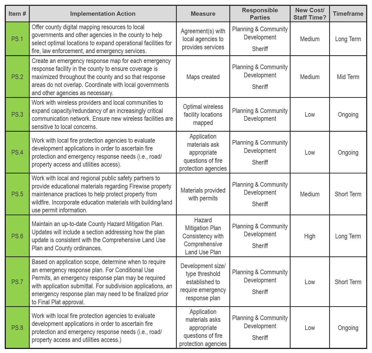
Public Safety Goals, Objectives, & Implementation
Goal PS-1: Land use, transportation, utilities, and emergency services planning promote the highest level of safety for St. Louis County residents.
Objectives
PS-1.1: Ensure that new development and redevelopment maintains or improves upon the planning area’s emergency response capabilities.
PS-1.2: Ensure that new subdivision development or large projects create and provide to the county an emergency response plan.
PS-1.3: Ensure that county Hazard Mitigation Plan updates are consistent with the County Comprehensive Land Use Plan and county ordinances.
Implementation
About
Learn more about the St. Louis County Comprehensive Land Use Plan.
Appendices
View report appendices.
Contact
Contact us with questions or for more information.
County Land Explorer
Visit St. Louis County's GIS website. You will be redirected to the site in a new window.