
Executive Summary
Intent
The County Comprehensive Land Use Plan establishes a long-term vision for managing land use where the county maintains zoning jurisdiction. The Plan’s overall intent is to support county goals and objectives for growth, development, and conservation, and to provide for the well-being of the county’s residents. For many years, St. Louis County had been operating with a largely outdated patchwork of smaller plans. The intent of this document is to provide one go-to planning resource, while recognizing townships that wish to be actively involved with the county in land use planning.
County land use patterns are shaped by many other aspects of planning, from economic development to transportation and environmental protection. Therefore, the Plan takes a comprehensive approach, looking at the capacity of land use planning to influence each of these aspects, and vice versa. The County Comprehensive Land Use Plan is based on careful considerations of growth projections, resource potential, infrastructure availability, and public service areas. The analysis of these features is joined with input from local, state, and federal agencies, and most important of all, the public and local leaders who reside and work in St. Louis County.
How to Use this Document
Plan Organization
The County Comprehensive Land Use Plan is organized into 6 elements. Click on the element name below to navigate to that section:
The Plan is focused primarily on land use – hence its title, “Comprehensive Land Use Plan”. The Land Use element builds from many of the other elements.
Goals, Objectives, and Implementation
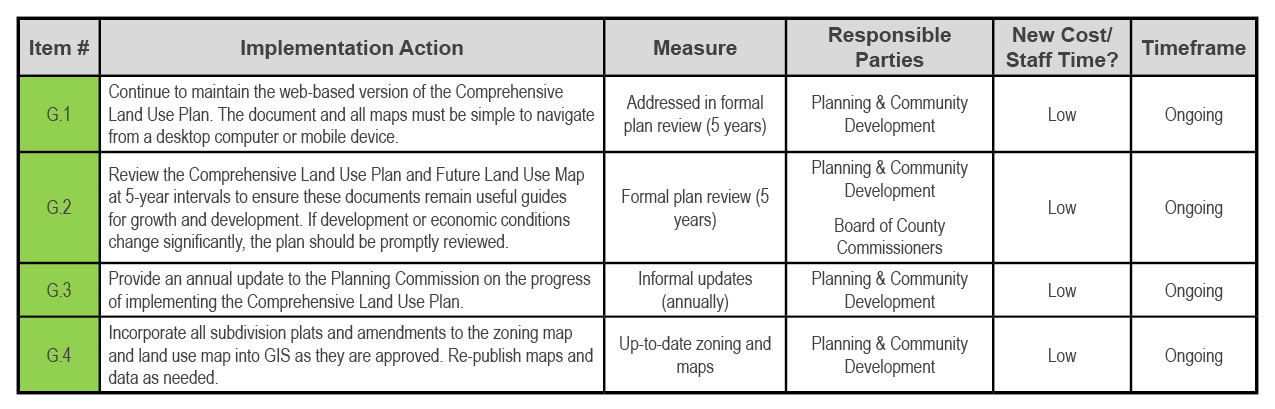
Each element provides a list of goals, objectives, and implementation actions. The implementation tables include a list of action items with measurable indicators to help county staff track progress toward achieving their goals.
The implementation tables were prioritized with stakeholder input. Each implementation action item includes the following:
- Item number – items are numbered in order of priority ranking, as determined by input from the focus groups, township leadership, the Planning and Community Development Department, the County Planning Commission, and the Board of County Commissioners.
- Full action item description.
- Measure by which each action item can be monitored.
- A rough cost ranking (low, medium, high) based on staffing/funding needs.
- An appropriate timeframe for implementation: ongoing, short-term (1-2 years), mid-term (3-5 years), or long-term (6-10 years).
- The party or parties which are expected to be responsible for carrying out the action. The primary party is listed first. Each action number is color-coded to represent the primary party:
General goals, objectives, and implementation items are given below. This framework is used throughout the County Comprehensive Land Use Plan.
Goal G1: The County Comprehensive Land Use Plan and Future Land Use Map are accessible, living documents.
Objectives
G-1.1: Update the County Comprehensive Land Use Plan and the Future Land Use Maps as growth and technological conditions change in St. Louis County.
G-1.2: The Future Land Use Maps provide basic guidance on the predominant type of land use to be expected in areas of county zoning jurisdiction and all zoning map decisions.
Implementation
Plan Authority
St. Louis County may only regulate lands within its jurisdiction. Therefore, the County Comprehensive Land Use Plan emphasizes lands within county jurisdiction. Non-jurisdictional areas include incorporated municipalities, tribal lands, state and federal lands, and townships which choose to exercise their own zoning authority. These areas are grayed out on all land use maps.
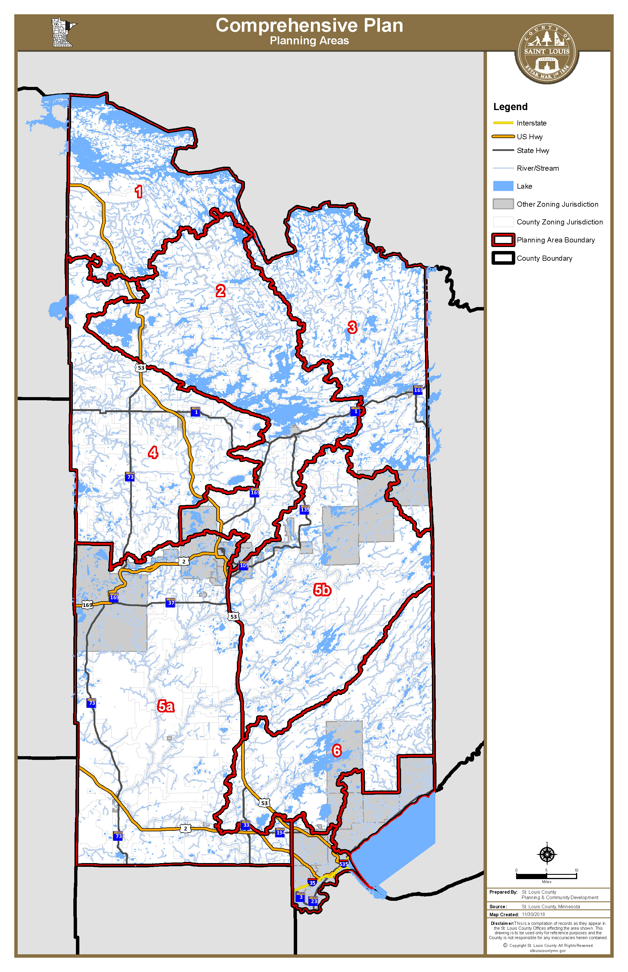
St. Louis County is the largest county in Minnesota. To make this document and the planning process more manageable, the study area was divided into seven sub-planning areas. The boundaries of these sub-planning areas are based on watershed boundaries. (Figure A).
Figure A – Planning Sub-Areas
Future Land Use Maps
This Plan includes a Future Land Use Map for each sub-planning area. These maps are attached to this document as Appendix C. The maps are also available on the Plan website, www.planslcmn.com. The Future Land Use Maps provide the framework that guides all changes to the zoning map. The maps define land use categories as opposed to zoning districts. Land use categories are broadly defined as opposed to zoning districts which specifically detail lot size regulations, structure location requirements, and which uses are allowed, not allowed, or conditional. For example, there is one Forest and Agriculture land use category, but multiple Forest Agricultural Management (FAM) districts—FAM 1, FAM 2, and FAM 3, each defined by a different minimum lot size requirement. Some land use categories provide a clear indication of the intended future land use and other land use categories simply indicate general locations that can support future growth and development.
As the County Comprehensive Land Use Plan is implemented, the county will use zoning at its discretion to ensure that there is always an appropriate supply of buildable land to support its development needs, while conserving natural resources and the county’s heritage, in accordance with the goals and objectives set forth in this document.
Land Use vs. Zoning
This Plan is not legally binding, but is intended to show local consensus on future land use and serves to inform all future land use decisions made by the Planning Commission, the County Board of Adjustment, and other county departments. All zoning and related ordinances, such as the subdivision ordinance, are legally binding and intended to be consistent with what is provided in this Plan.
This Plan is a Blueprint
The Plan provides a blueprint for managing growth, development, conservation, and other land use objectives in St. Louis County. The county government can use many tools to implement the Plan, including zoning. Zoning is legally binding, but the Plan is not. However, the Plan provides the rational basis for developing zoning and other policies to serve the interests of St. Louis County and its residents.
Public Involvement Summary
The County Comprehensive Land Use Plan was developed with broad public and stakeholder input. This input directed much of the goals, objectives, and implementation actions contained in this Plan, as well as helped to shape the Future Land Use Map. The core elements of public input are highlighted below:
Public Workshop Series
Two series of public workshops were conducted in Virginia, Ely, Orr, and Pike Lake. The intent of the meeting locations was to better reach residents throughout the county. The first workshop series was held August 21-24, 2017, and the second series was held July 16-19, 2018. The workshops involved a presentation, question and comment period, and mapping activities. The first workshop series focused on input on existing land use characteristics and local values. The second workshop series sought input on alternative future land use maps and draft goals and objectives.
Township Involvement
Townships were an integral voice in the development of the County Comprehensive Land Use Plan. In addition to involvement in several public meetings, upon request several townships were personally visited by county staff to review elements of the Plan through 2017 and 2018. County staff also presented information about the County Comprehensive Land Use Plan and received input at the 2018 Township Association meeting in Cotton.
Focus Group Involvement
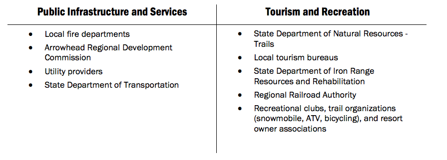
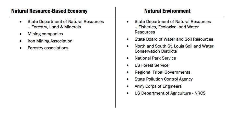
Governmental agencies and other regional and local interests were represented through involvement in four focus groups, as detailed below. Focus group meetings were held in August 2017 and July 2018. Each focus group provided comments on the Land Use Report and evaluated the draft implementation actions.
Online Outreach and Input
A website was maintained throughout project development (planslcmn.com). The website served as a repository for project-related documents and background information. Periodic email blasts were sent to all those who attended meetings and provided their email addresses, in addition to the county’s extensive list of stakeholders.
As part of initial public input efforts in August 2017, an online “Wiki Map” was made available through November 2017. Participants were able to select a “pin” to identify and provide detail on a land use related concern, valued amenity, favorite characteristic, or favorite place for consideration in the development of the Future Land Use Maps.
Appendices
The following items are appended at the end of this document. Click on the heading to navigate to each section.
Appendix A – Glossary of Terms
Some of the terms contained in this document that require explanation are described in the glossary. These terms are used often in the planning practice and government circles, but are seldom used otherwise.
Appendix B – Focus Group and Public Workshop Summary
The summary contains records from the public workshops series and focus group meetings.
Appendix C – Future Land Use Maps
Appendix C contains each Future Land Use Map. The maps are also available on the County Land Explorer here.
Land Use Report
The Land Use Report provides a profile of St. Louis County in 2017. The Report was developed to provide a data-driven foundation for the County Comprehensive Land Use Plan. The Report also provides projections of future population, employment, and housing demand. Key takeaways for consideration in the Plan document are also noted from insights into the compiled data.
About
Learn more about the St. Louis County Comprehensive Land Use Plan.
Appendices
View report appendices.
Contact
Contact us with questions or for more information.
County Land Explorer
Visit St. Louis County's GIS website. You will be redirected to the site in a new window.